
Study Guide
Field 049: Social Studies—Geographical Perspectives
Sample Multiple-Choice Questions
Objective 0001
Geographic Terms and Concepts (Standard 1)
1. The demographic transition model was developed primarily to explain the:
- social and cultural changes resulting from high levels of in-migration.
- effect of population movement from rural to urban areas.
- population changes caused by large short-term changes in birth rates.
- effect of changing death and birth rates on total population.
- Answer
- Correct Response: D.
This question requires the examinee to demonstrate knowledge of spatial interaction, demographic cycle, cultural diffusion, patterns, relationships, and other basic geographic terms and concepts. The demographic transition model illustrates the effects of economic development on population growth by showing the developmental stages through which low birth and death rates come to replace high birth and death rates in a given area or region.
Objective 0001
Geographic Terms and Concepts (Standard 1)
2. A geographer is analyzing global trade routes in the era of sailing ships. Which of the following two essential elements of geography would likely form the conceptual bases of the geographer's study?
- human systems and environment and society
- physical systems and places and regions
- human systems and the world in spatial terms
- physical systems and the uses of geography
- Answer
- Correct Response: C.
This question requires the examinee to demonstrate knowledge of the six essential elements of geography (i.e., the world in spatial terms, places and regions, physical systems, human systems, human-environment interactions, and the uses of geography). Analyzing global trade routes in the era of sailing ships requires an understanding of the patterns and networks of economic interdependence across Earth's surface. Such networks are a major feature of the essential geographic element of human systems. An examination of global trade routes during this period also involves an analysis of the world in spatial terms, the relationships across space between people, places, and environments.
Objective 0002
Geographic Tools, Sources, and Research Skills (Standard 2)
3. A medical geographer researching the spatial distribution of asthma among children 12–17 years of age in a major U.S. city hypothesizes that there is a link between poverty and the prevalence of the disease. Which of the following research strategies would best enable the geographer to explore that hypothesis?
- interviewing health-care workers concerning their observations of adolescents whom they have treated for asthma
- using a geographic information system to correlate places of asthma occurrence with socioeconomic data related to zip codes
- creating a spreadsheet that lists known cases of asthma by age and place of residence
- distributing survey questions to asthma sufferers in selected neighborhoods with different socioeconomic characteristics
- Answer
- Correct Response: B.
This question requires the examinee to demonstrate knowledge of sources of geographic information, characteristics and uses of geographic systems, and geographic tools and technologies. Geographic information systems, which digitally create spatial areas, use sophisticated software to organize, manipulate, and analyze diverse forms of geographic data. Such a system would be a particularly effective means of correlating places of asthma occurrence with the socioeconomic characteristics of those places to determine whether there is a link between poverty and the prevalence of the disease.
Objective 0002
Geographic Tools, Sources, and Research Skills (Standard 2)
4. Use the map below showing the main agricultural regions in China to answer the question that follows.
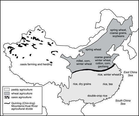
To explain the origins of the regional difference in Chinese agricultural production shown in the map, which of the following types of information would be most useful?
- a knowledge of the variations in China's physical geography and climate
- a knowledge of the different types of planting and harvesting techniques used by farmers in China
- a knowledge of China's international trade relationships
- a knowledge of the labor inputs required to produce various types of agricultural goods
- Answer
- Correct Response: A.
This question requires the examinee to demonstrate knowledge of basic cartographic concepts and how to interpret information in maps, charts, diagrams, and other graphic formats. Physical geography and climate are the primary determinants of those forms of agricultural activity that are most appropriate in a given region. Whereas a sloping topography and scarce rainfall limit large parts of western China to oasis farming and herding, many eastern areas of the country possess physical attributes that make them well suited for extensive production of various types of grains.
Objective 0003
Physical Systems (Standard 3)
5. Use the information below to answer the question that follows.
• fluctuating water table
• large herbivores, carnivores, and scavengers
• tall, coarse grass
• low-growing, drought-resistant tree species
The information presented best describes major features of which of the following grassland biomes?
- steppe grasslands
- midlatitude grasslands
- prairie grasslands
- tropical savanna grasslands
- Answer
- Correct Response: D.
This question requires the examinee to demonstrate knowledge of the distribution and characteristics of major global and regional ecosystems. Major tropical savanna grasslands can be found in northern and eastern India, northern Australia, south central Africa, western Central America, and the Llanos region of Venezuela. Their major features include fluctuating water tables, leached soils, large herbivores, carnivores, and scavengers, tall, coarse grass, and scattered low-growing, drought-resistant trees, scrub, and thorn bushes.
Objective 0003
0003 Physical Systems (Standard 3)
6. Use the maps below to answer the question that follows.
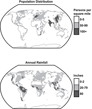
Which of the following statements most accurately interprets information shown in the two maps?
- High levels of rainfall are generally necessary to support high levels of population.
- Regions of the world with the highest levels of precipitation generally have the lowest levels of population density.
- Low levels of rainfall generally cannot support high levels of population.
- Regions of the world with the lowest levels of precipitation generally have the highest levels of population density.
- Answer
- Correct Response: C.
This question requires the examinee to demonstrate knowledge of the effects of physical factors such as climate, topography, and location on population distribution, patterns of work, industry, agriculture, and transportation. Information presented in the two maps shows that population densities of 0-5 persons per square mile are most common in regions that receive 0-2 inches of rainfall annually.
Objective 0004
Human Systems (Standard 4)
7. Compared with North American cities, western European cities are generally more compact, with lower skylines, narrower streets, and more irregular street patterns. This difference is primarily a reflection of the:
- different cultural values of the two regions.
- more abundant land resources of North America.
- greater age of European cities.
- different political systems of the two regions.
- Answer
- Correct Response: C.
This question requires the examinee to demonstrate knowledge of the purposes, organization, and functions of diverse human settlements; processes influencing the establishment of human settlements; and the ways in which settlements change over time. The compact form, low skylines, narrow streets, and irregular street patterns of many western European cities are vestiges of their medieval origins. Although current urban patterns in the region are largely the product of nineteenth- and twentieth-century construction programs, builders very often retained major features of the earlier urban landscape.
Objective 0004
Human Systems (Standard 4)
8. Use the graph below to answer the question that follows.
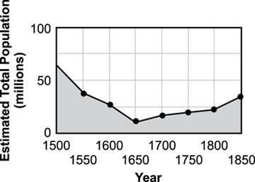
The graph best illustrates the effect of European exploration, conquest, and settlement during the Age of Discovery on demographic patterns in which of the following world regions?
- Sub-Saharan Africa
- South America, Central America, and the Caribbean
- Southeast Asia
- North Africa and the Middle East
- Answer
- Correct Response: B.
This question requires the examinee to demonstrate knowledge of human migrations and the causes and effects of population movement within and between world regions. Information presented in the graph illustrates the devastating effect that the introduction of European diseases had on the indigenous populations of Latin America and the Caribbean during the Age of Discovery.
Objective 0005
Places and Regions (Standard 5)
9. Geographers would most likely use the term shatter belt—an area of recurrent political division and fragmentation—to describe which of the following regions of Europe?
- Baltic States
- Balkan Peninsula
- British Isles
- Iberian Peninsula
- Answer
- Correct Response: B.
This question requires the examinee to demonstrate knowledge of the physical and human characteristics of different world regions. The political and ethnic conflicts of the late twentieth century were only the last in a long series of struggles that have made the Balkan Peninsula a good example of what geographers mean when they use the term shatter belt, a region that tends toward fragmentation from the effect of powerful colliding cultural and political forces.
Objective 0005
Places and Regions (Standard 5)
10. Use the map below to answer the question that follows.
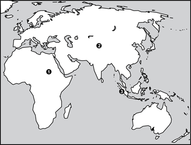
Which of the following is the main religion of the three numbered areas on the map?
- Hinduism
- traditional folk religions
- Islam
- Buddhism
- Answer
- Correct Response: C.
This question requires the examinee to demonstrate knowledge of economic, cultural, and political connections within and between major world regions and places. About 97% of the people of Sudan (area 1) are Muslims. A similar or slightly higher proportion of the populations of Pakistan, Afghanistan, and Tajikistan (area 2) are also adherents of Islam, which is the main religion of Indonesia (area 3), where about 87% of the people base their faith on the teachings of Muhammad.
Objective 0006
Human-Environment Interactions (Standard 6)
11. The global distribution of different types of terrestrial biomes is most directly influenced by:
- soil characteristics.
- biotic factors.
- topographic features.
- climatic factors.
- Answer
- Correct Response: D.
This question requires the examinee to demonstrate fundamental knowledge of global ecosystems. Climatologists have found that the presence of certain plants, soils, and even animals in a given region is most closely associated with climate, which is a major determinant of living conditions in terrestrial biomes.
Objective 0006
Human-Environment Interactions (Standard 6)
12. Historians believe that a prolonged cycle of severe droughts in the Southwest contributed to the collapse of the highly developed Anasazi culture of Chaco Canyon by forcing the dispersion of a centralized agricultural civilization into smaller, less stable settlements. This development best illustrates the:
- relationship between carrying capacity and population size.
- cultural consequences of human modifications of the environment.
- economic consequences of territorial expansion.
- relationship between land-use choices and political structure.
- Answer
- Correct Response: A.
This question requires the examinee to demonstrate knowledge of how the physical environment affects humans. Carrying capacity refers to the number of people supportable by an area's known and usable resources. When an area's carrying capacity declines, as would happen during a prolonged cycle of severe droughts, its population invariably drops as well.
Objective 0007
Uses of Geography (Standard 7)
13. Climatic factors most influenced the outcome of which of the following events?
- the Norman conquest of England in 1066
- the Black Death in Europe between 1346 and 1352
- the Spanish conquest of the Aztecs in 1521
- the French invasion of Russia in 1812
- Answer
- Correct Response: D.
This question requires the examinee to demonstrate knowledge of geographic factors influencing the origins, major events, and consequences of global exploration, territorial expansion, conquest, and colonization. As happened to German armies during World War II, Napoleon's forces had an extremely difficult time adapting to the harsh Russian winter. Once Napoleon's soldiers began their retreat from Moscow, the punishing weather and scarcity of supplies devastated their ranks. By the time they reached Poland, fewer than 100,000 men remained alive from the 600,000 French troops who had marched into Russia five months earlier.
Objective 0007
Uses of Geography (Standard 7)
14. Which of the following have been the most important geographic factors contributing to the Israeli-Palestinian conflict?
- population growth and limited water supplies
- desert topography and limited transportation networks
- economic growth and limited mineral resources
- diverse languages and limited educational resources
- Answer
- Correct Response: A.
This question requires the examinee to demonstrate knowledge of the influence of geography on contemporary issues associated with population growth, natural resources, and patterns of global interaction, cooperation, and conflict. The desert conditions characteristic of large parts of the area occupied by Israelis and Palestinians have made access to limited water supplies a major concern of people living in the area. Population growth among both Israelis and Palestinians has intensified competition for this vital resource.
Objective 0008
Geographic Instruction and Assessment (Standard 8)
15. Which of the following instructional strategies would best help middle grade students evaluate the relative merits of maps and other geographic representations in solving geographic problems?
- Have students prepare sketch maps illustrating the spatial dynamics of contemporary and historical events.
- Have students choose the most appropriate maps and graphics from an atlas to answer specific questions about selected geographic issues.
- Have students compile information from various media and then transform the primary data into maps, graphs, tables, and charts.
- Have students interpret aerial photographs or satellite-produced images to locate and identify physical and human features.
- Answer
- Correct Response: B.
This question requires the examinee to demonstrate knowledge of instructional strategies for promoting student learning and fostering the development of critical-thinking, problem-solving, and performance skills in the social studies. Having students select the most appropriate maps and graphics from an atlas to answer specific geographic questions requires them to make the kinds of judgments that form the basis of sound evaluative skills. The more such practice students have, the better able they will be to assess the relative merits of various geographic representations in addressing geographic problems or questions.